Vision 2030: A Regional Spatial Strategy for Metro Luzon
This first appeared in BluPrint Volume 2 2016. Edits were made for BluPrint online.
Urban population growth in Metro Manila continues at a very high rate in both internal growth and in-migration. This growth has spilled over to towns and cities within a 50-kilometer radius of the metropolis. At the same time, similarly high urban population growth is happening in the larger cities within 100 kilometers of Metro Manila, such as the cities of San Fernando, Angeles, and Mabalacat in Pampanga; and Lipa and Batangas City in Batangas. The growth rates in some of these cities are even higher than that of Metro Manila, and like Metro Manila, all of them are experiencing the negative consequences of unplanned and ill-managed urban growth.
Without an effective land use and transport policy that rationally relates these urban centers to each other, the result is increasing traffic congestion, inadequate housing, deteriorating urban basic infrastructure, and services, premature and improper conversion of agricultural lands into urban uses, and encroachment into flood plains, river basins, and other danger zones, which exposes thousands of people to increasingly frequent and devastating disasters.
Metro Manila, CALABARZON, and Central Luzon, which can collectively be called the Metro Luzon Region (MLR), are the top three contributors to the country’s GDP, but ironically, the chaotic urban growth in these areas has resulted in social injustices and inequity that invariably disadvantage the poor. With two-fifths of our population living in MLR, we need to formulate a regional spatial strategy that shapes and enables a just and equitable society.
I. METRO LUZON REGION’S SPATIAL DEVELOPMENT
A. Factors Influencing Urban Growth Patterns
Urban growth in the Philippines has traditionally been linear, running along major roads and highways, thus creating long stretches of urban areas and longer commuting distances. The lack of secondary and tertiary roads contributes to the situation. The absence of an efficient mass transport system makes the situation worse as commuters travel long distances and waste precious time traveling to their destinations. This translates to significant economic losses and worsening urban air quality.
[one_half padding=”0 15px 20px 0″]

This situation is evident in the urban centers of the MLR. Before the construction of the North Luzon Expressway (NLEX), the MacArthur Highway served as the main transport route from Metro Manila to the towns and cities of Central and Northern Luzon. Similarly, before the construction of the South Luzon Expressway (SLEX), the old Manila South Road, which passes through the towns and cities of Laguna and onwards to Batangas and Quezon, was the main transport route in CALABARZON. In both cases, the most intensive urban growth occurred along these two major roads, with Metro Manila connecting the two in one long urban corridor.
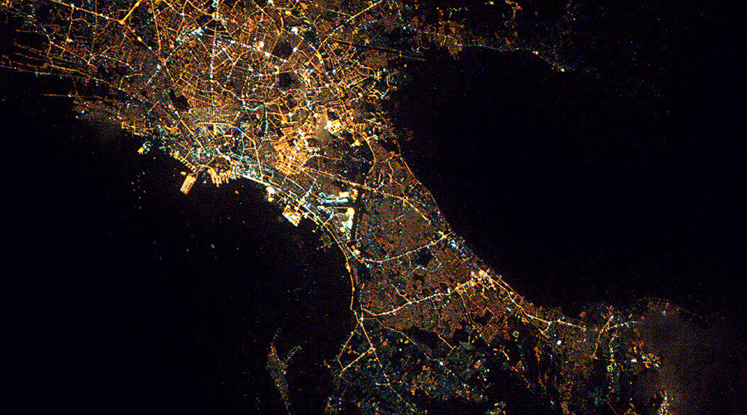
Satellite images show a distinct north-south urban growth pattern of the MLR with Metro Manila in the middle. However, growth starting from Metro Manila is more intensive in a southward direction, which can be explained by several reasons. (See Fig. 1)
One is that SLEX has service roads on both sides, thus facilitating urban development up to Alabang where the service roads end. NLEX, on the other hand, has no service roads. Another reason is that agricultural lands alongside SLEX were not covered by the Agrarian Reform Law and thus were more easily converted from agricultural to urban uses, whereas agricultural lands alongside NLEX are predominantly planted to rice and therefore covered by said law. Another reason for the lands along NLEX remaining agricultural in land use is the existence of the Candaba Swamp and the Pampanga River Delta, which flood every rainy season and remain waterlogged even during part of the dry season.
Development in the south of Metro Manila had also been greatly induced by the existence of large tracts of land under single ownership, such as the 7000-hectare former Canlubang Sugar Estate and the 2000-hectare land owned by Jose Yao Campos. In the real estate development industry, developers prefer such lands because they avoid the difficulty of assembling many land parcels owned by different people. In the north, the largest land parcels under single ownership are already in the Pampanga and Tarlac area.
YOU MIGHT LIKE: How do we make sure Asia’s megacities are healthy cities?
B. The Synergy between Central Luzon, Metro Manila, and CALABARZON
1. Expansion of Metro Manila
The rapid growth of population in the Metro Manila area is manifested in the extent and influence of its urban development, which can be both seen and felt well beyond the boundaries of the metropolis. Encouraged by cheaper land and services, but still, within relatively easy access to Metro Manila, predominantly private sector-led investments can be found beyond the northern, eastern, and southern administrative boundaries of the metropolis. Most of these, however, have been undertaken in a piecemeal, unplanned, and uncoordinated manner, often built upon flood plains and river basins, thus exposing a large number of people to floods, and prematurely eating up productive agricultural land, and creating more traffic.
The physical pressures exerted by an increasing and uncontrolled population growth rate and expanding industries have extended Metro Manila’s urban built-up area into 1.) the cities and towns of the provinces of Bulacan in the north along the MacArthur Highway and near the exits of NLEX; 2.) the municipalities of Cainta, Taytay, San Mateo, Montalban, Antipolo, Angono and Binangonan in the province of Rizal to the east, along the Ortigas Avenue Extension and Manila East Road; 3.) the municipalities of Bacoor, Imus, Dasmariñas, and Silang in Cavite Province along the General Tirona National Road and the General Aguinaldo Highway respectively in the southwest; and 4.) the municipalities of San Pedro, Biñan, Sta. Rosa, Cabuyao, and Calamba in Laguna Province along SLEX and the Old Manila South Road.
Further north at a distance of around 100 kilometers are the highly urbanized and rapidly urbanizing cities of San Fernando, Angeles, and Mabalacat, which, together with the Clark International Airport and Special Economic Zone, are coalescing into a major metropolitan area. Further south are the similarly rapidly growing cities of Lipa, Batangas, and Lucena. Batangas City and its adjacent cities and municipalities, namely San Pascual, Bauan, Ibaan, Taysan, and Lobo, are one of the country’s emerging metropolitan regions. (See Fig. 2)
2. Population and migration
Central Luzon, Metro Manila, and CALABARZON together comprise the three most populous regions in the Philippines, which collectively account for 40% of the country’s population. The fastest-growing areas are those located on the periphery of Metro Manila. A key element of this growth is the entry of migrants. The three regions are among the top five destinations of migrants because of opportunities for gainful employment and access to better amenities.
The mobility of people between Central Luzon, Metro Manila, and CALABARZON shows both inward and outward movement—residents of Metro Manila have moved to the adjacent regions, while those of Central Luzon and CALABARZON still see Metro Manila as the land of opportunity.

3. Employment
With the concentration of labor-intensive establishments in Metro Manila and the adjacent municipalities of Bulacan, Rizal, Laguna, and Cavite, the three regions account for more than 30% of the total employed population of the country, and about 50% of the total non-agricultural employed persons. However, the three regions have a majority of all recorded unemployed, a symptom of the social and economic problems of rapidly urbanizing areas.
4. Commodity and services exchanges
Metro Manila serves Central Luzon and CALABARZON as 1.) the major market for their agricultural products; 2.) the destination of students seeking education, and of people seeking medical services and facilities; 3.) a major shopping center for finished products; and 4.) the gateway for people, goods, and services to and from the rest of the country and abroad.
In return, Metro Manila looks to the adjacent regions as 1.) its major source of food supply; 2.) a key source of manpower; and, 3.) a nearby area for recreation and leisure activities. The municipalities on the immediate fringes have served as sources of land for residential and industrial development and for main infrastructure such as water supply. Also, they have been the destination for the relocation of Metro Manila’s squatters, and sites for the disposal of solid waste.
5. Previous government actions to decrease the primacy of Metro Manila
Since the late 1960s, it has been the official government policy to decrease the primacy of Metro Manila and encourage the growth and development in other regional urban centers and their rural hinterlands. Based on this policy, the national government undertook such actions as the construction of NLEX and SLEX, the development of the Bataan and Cavite Export Processing Zones together with the provision of fiscal and non-fiscal incentives to investors in these areas, the construction of the Batangas Seaport, and more recently the development of the Southern Tagalog Arterial Road (STAR), and the Subic and Clark special economic zones.
Despite these policies, projects, and package of incentives, Metro Manila continues to attract migrants and investors. However, because of cheaper land and services outside Metro Manila, the different urban centers in Central Luzon and CALABARZON have grown. Statistics show that after Metro Manila, these two regions have attracted the most number of new investments, including foreign direct investments, than other regions in the country.
READ MORE: BCDA Pres tackles USD 5 billion New Clark City, white elephants
6. Recent government policies
In recognition of the relative attraction of the three regions in terms of population growth and economic investments, the national government has given priority and support to the development of the provinces of Cavite, Laguna, Batangas, Rizal, and Quezon under the program known also as CALABARZON. In 2003, CALABARZON had 64 Special Economic Zones (SEZs). Even the World Bank, in response to government request, provided technical assistance to the preparation of development plans for Cavite and Laguna, known as the CALA project.
More recently, with the advent of the Business Process Outsourcing (BPO) industry in the last decade, the number of SEZs has considerably increased. The result is the large migration into CALABARZON, making it the second densest region in the country, next to Metro Manila. The region has the following infrastructure and services:

7. The Philippine Development Plan 2011-2016
The plan cites that the country needs to develop suitable locations to ensure that BPO investments and expansions can be accommodated, and that physical and Information Technology (IT) infrastructures are key solutions to address the growth of the industry. In 2009, the government and the private sector collaborated on a project dubbed “Next Wave Cities,” focusing on locations with high growth potential in the BPO services. Among the 10 cities identified, six are in CALABARZON: Sta. Rosa in Laguna, Metro Cavite (Bacoor, Dasmariñas, Imus), Lipa and Batangas City in Batangas, and Malolos, Bulacan, in Central Luzon. In 2010, five other cities were added as BPO potential destinations. One of them is Metro Subic in Central Luzon.
The Philippine Development Plan (PDP) also prescribes strengthening the country’s international logistics and supply chain activities and specifically cites the existing ports in Batangas and Subic, not only to decongest Metro Manila but also to open opportunities to worldwide shipping in the new areas. Also cited is the strengthening of the integrated air and sea connectivity of Clark-Subic to enhance the profile of this growth center among foreign and local investors.
8. The Subic-Clark-Manila-Batangas Corridor
Prior to the current PDP, the Medium Term Philippine Development Plan (MTPDP) 2004-2010 already recognized the need for a transport logistics system that would decongest Metro Manila via efficient linkages between its business centers and nearby provinces. In 2007, the Subic-Clark-Manila-Batangas (SCMB) Corridor, which connects the three regions, was envisioned as a major transshipment and logistics hub in the Asian region. The SCMB Corridor handles more than 80% of the volume of the national cargo throughput, but its potential has been constrained by inefficient logistics operations and infrastructure support. According to the MTPDP, this resulted in high transport costs of goods and services that have made the corridor less competitive. To address this, the MTPDP prescribed a seamless multimodal logistics system along the SCMB Corridor to support intra-regional trade and investment, increased level of services of an integrated transport system, and an efficient flow of commodities, supplies, and inputs to tourism areas and various economic and industrial zones.
The current PDP’s strategic plan with respect to the transport sector specifically highlights the need to develop an integrated multimodal logistics and transport system. It states: “The SCMB Corridor and other strategic logistics corridors must be developed to become a seamless intermodal logistics corridor…The extension of the SCMB logistics corridor farther to the north and to the south will also be pursued. To support this, the viability of establishing an efficient long-distance, high-speed mass rail transit system, integrated with the mass transit commuter rail system in Metro Manila, shall be explored… The feasibility of freight-rail services for all strategic logistics corridors will also be considered.”
YOU MIGHT LIKE: What does inclusive street design look like?
9. Central Luzon Regional Development Plan 2011-2016
This plan further strengthens the policies of the PDP, with a particular focus on Central Luzon. Its objectives include 1.) increased level of services of strategic roads and north-south linkages; 2.) integrated land, air, and sea transport modes; and 3.) development of Clark-Subic as a regional tourism hub. (See Fig. 3) The plan capitalizes on its strength as a major logistics hub, its being a major agricultural and food production area of the country, as well as its strong tourism potential. In physical development terms, the plan continues to adopt the “Enhanced ‘W’ Growth Corridor” spatial strategy, (See Fig. 4) with the Clark International Airport and its adjoining cities of Angeles and Mabalacat in the center.
10. CALABARZON Regional Development Plan 2011-2016
This plan acknowledges the need for developmental support to the province of Quezon because it lags behind the other provinces of the region, according to the Human Development Index. It also recognizes the dominant influence of the private sector in defining housing and real estate development in the region, noting that master-planned developments tend to locate along major roads. The region (particularly in Rizal, Laguna, and Cavite) has been a favorite location for government-developed resettlement sites for informal settlers. The plan espouses the rehabilitation of the PNR and further development of the Batangas Port as a high priority. It envisions the region as a major alternative residential and commercial node to Metro Manila. However, the plan cites a number of challenges, such as 1.) inadequate transport infrastructure; 2.) unbalanced distribution of settlements; 3.) limits to the use of land and other natural resources; 4.) disaster risk reduction and climate change adaptation concerns; and, 5.) inadequate public service.
In physical development terms, the plan has adopted the “Cluster/Center Corridor Wedge” spatial strategy, which aims to direct and stimulate development and growth west to east, as well as strengthen the north-south corridor. This strategy specifically cites that “Proposed land uses and urban developments will be grouped in clusters, each borne from the predominant conditions, existing strengths, and potential opportunities of each area. Examples of land-uses in the west include beach and mountain tourism, waterfront mixed uses, agropolis or highly-specialized agricultural and urban development in Batangas, agro-industrial uses, metropolitan and commercial urban development in Batangas City.”
II. PROPOSED SPATIAL DEVELOPMENT STRATEGY FOR METRO LUZON
Building upon the prevailing conditions, development policies, plans, and programs, emerging trends, as well as major opportunities in Central Luzon, Metro Manila, and CALABARZON (or MLR), the proposed spatial development strategy is basically a north-south transport-oriented development (TOD) corridor, with three major metropolitan areas: 1.) Metro Clark area in the north; 2.) Metro Batangas area in the south; and, 3.) Metro Manila in between the two.
In order to accommodate further growth of the three metro areas but avoid the negative effects of continuous ribbon development, however, and considering the distance between Metro Manila and the two other metro areas, the spatial strategy also envisions the development of “new towns”—one in Bulacan in the vicinity of Malolos near a commuter train station, and the other in Batangas in the vicinity of Tanauan and Malvar, also near a commuter train station. (See Fig. 5) This strategy is based upon the following considerations:
- The dominant influence of the NLEX-SCTEX and the SLEX-STAR expressways, as well as the proposed Integrated Luzon Railway, in the development of urban centers;
- The individual strengths and opportunities of, as well as the synergy between, the three metro areas, with a multimodal transport system as the integrating backbone;
- The fact that each of the three metro areas is or becoming self-sufficient and self-sustaining economic clusters, each with its own distinct but complementary primary function;
- The distance between Metro Manila and the two other metro areas is too long for commuting and, therefore, warrants development of intermediate or satellite townships where people can live and have the choice of metro areas for employment.
The major expressways need not traverse the proposed new towns since the lands that are easily accessible are already very expensive, especially in Batangas. Sites for the new towns, however, should be near enough to exits of the expressways, say within 1 to 3 kilometers.

III. RECOMMENDED LAND USE POLICIES
A. General Land Use Policies
The spatial development strategy envisions a policy that defines land use in the MLR in the four general categories, namely: Production Land, Protection Land, Settlements Land, and Infrastructure Land. In broad terms, productive agricultural lands already identified as Strategic Agricultural and Fisheries Development Zones (SAFDZ) are defined as Production Land. Environmentally sensitive areas defined by DENR, such as designated National Forests, erosion-prone areas, watersheds, floodplains, river basins, mangroves, and other critical eco-systems are designated as Protection Zones. Existing built-up and planned urban areas are defined as Settlements Land. And finally, easements and rights-of-way for roads, water reservoirs, irrigation canals, power transmission lines, flood control structures, and other utilities are defined as Infrastructure Land. Each of these major land categories should have clearly defined guidelines on specific allowable land uses and activities, as well as the conditions for their continued presence.
B. Metro Clark and Metro Batangas
It is recommended that their current development policies, plans, and programs as approved by NEDA be pursued. These provide the framework for defining the appropriate land uses for these two metro areas. However, we need more detailed land use, zoning, land management, and implementation plans for the specific areas where stations of the long-distance and commuter rail lines will be located in order to optimize the socio-economic benefits these stations will generate. These station locations offer great potential for the development of “transit-oriented developments” or TODs, which can accommodate a mix of land uses, especially social housing. The plans for these TODs should be crafted in such a manner that they can be implemented as real estate development projects through public-private partnerships (PPP).
C. New Towns
While specific sites for new towns still need to be identified and defined, we propose that the dominant land use for these areas be residential, particularly social housing, supported by a mix of compatible land uses, including commercial and retail facilities as well as schools and health care facilities that can cater to the immediate needs of its residents within short travel distance. We propose locating retail facilities and its compatible land uses near the commuter train stations.
IV. NEW TOWNS DEVELOPMENT CONCEPT
A. Basic Function
In contrast with the traditional definition of new towns, which are self-contained communities, the new towns in the MLR are envisioned to initially function as “bedroom communities,” which means they will start as predominantly residential areas while the major job centers are in the metro areas (Metro Clark, Metro Manila, and Metro Batangas) approximately within a 30 to 50-kilometer travel distance. Their medium- and long-term plans, however, should provide for future growth and development including the introduction of other land uses to accommodate business and commercial enterprises that generate employment and livelihood opportunities, as well as the expansion of community facilities, infrastructure services, and utilities. The critical factors that can attract new residents to the new towns are the affordability (and financing schemes) of house-and-lot packages, and accessibility to public transport and basic social services.
It would be advantageous if the new towns would already include in initial phases of development the promotion of urban-type manufacturing enterprises (e.g., electronics, assembly of household appliances and automobiles, food processing, etc.), distribution industries (e.g., trucking, warehousing, wholesale outlets, etc.), and intensive agriculture (e.g., track farming, high-tech vegetable farming, etc.). These can be combined with small, compact urban centers around the commuter train stations. This strategy will offer an alternative location to the metro areas and, in particular, help decongest Metro Manila.
READ MORE: Harvard GSD Dean on why “sustainable” is not enough
B. Roles of the Public and Private Sectors
Given the circumstances surrounding the land to be developed as new towns, such as for example, the multiple ownership of the land area involved and the need for accessibility, the development of these new towns will necessarily involve both government and the private sector. The government in this case will include the local, provincial, and national, while the landowners and developers will comprise the private sector.
The delineation of roles between the public and private sectors will depend on how the development of the new towns is to be pursued. There is a wide range of options that can be considered. At one end of this range, government acquires the land and bids out its development and disposition to the private sector. This approach is similar to the manner by which former military bases were developed, such as the Bonifacio Global City and Newport City (former Villamor Air Base). At the other end of the range, government mandates the development of the site and provides support and incentives to the landowners concerned to develop it themselves.
A middle-ground option is where a public-private partnership is forged between the landowners, government, and private developers. Assuming that the middle-ground option is the most viable, the delineation of roles between the public and private sectors could be as follows:
Public Sector
1. National Government:
- Declaration of policy
- Provision of major access roads and utilities trunk lines
- Provision of fiscal and non-fiscal incentives to landowners and developers
- Facilitation of the necessary national government permits and clearances, and transfer of land titles if necessary
2. Provincial Government:
- Adoption of the spatial strategy in the Provincial Physical Framework Plan
- Provision of technical and institutional support to LGUs concerned
3. Local Government Units:
- Identification of land parcels, their owners, and assessed values
- Support to the private developers in the acquisition of the properties involved, or in the establishment of a Joint Venture arrangement between the landowners and developers
- Facilitation of the necessary permits and licenses required by the developer
- Provision of the appropriate social services and community facilities
Private Sector
1. Landowners:
- Sale of the properties involved to, or Joint Venture with, private developers
2. Private Developer(s):
- Preparation of detailed development plans
- Construction of approved improvements
- Marketing and sale of developed lots
- Establishment and initial management of the Homeowners Association
- Support to the LGU in the maintenance of roads and utilities


CONCLUSION
The current uncoordinated and unsynchronized urban growth of Central Luzon, Metro Manila, and CALABARZON—the Metro Luzon Region—is resulting in an enormous waste of resources and efforts, which could otherwise be pooled to cope with the increasing demand for infrastructure and services. While the MLR has maintained its dominance as the industrial “belt” of the country, the rate of growth of their industrial output is way below their potential because of the lack of necessary structural reforms and integrated land use, transport, and infrastructure development program.
Central Luzon and CALABARZON are vastly more developed than other regions of the country, partly because of their proximity to Metro Manila and partly due to their logistics services, particularly air and sea transport, as well as their vast agricultural hinterlands. They have a higher degree of economic activity as reflected in their more intensive concentrations of population and industry, which are substantially above national averages. However, their current spatial development patterns are incompatible with each other in terms of an integrated economic development strategy, which should capitalize on the synergy among the three regions in addressing their respective priority concerns, opportunities, and challenges.
The further growth of Central Luzon, Metro Manila, and CALABARZON is inevitable—that is, the physical extent of these areas will not only continue but even increase, merging into one huge megalopolis. The issue is not whether this is desirable or not, but rather how this growth can be accommodated such that its benefits can be enhanced and widely shared while, at the same time, preventing undesirable consequences from happening.
Human beings are social and spatial beings. Because of this, the social aspect of our lives shapes our spatial lives, and how we exist spatially impacts our society and the quality of our democracy. When we begin to think of the “spatiality” of social justice and injustice, it opens our eyes to more practical and effective strategies in urban planning and achieving genuine inclusive growth.![]()
BluPrint thanks the Subdivision & Housing Developer’s Association for inviting us to cover the 24th SHDA National Developers Convention, Building a Million Dreams: Stronger in Synergy, Towards a Green and Sheltered Nation, and for sharing with us materials presented at the convention.
Frequently Asked Questions
The primary goal of the strategy is to create an integrated, transport-oriented development corridor that connects Central Luzon, Metro Manila, and CALABARZON. By establishing structured growth centers and satellite new towns, the framework aims to curb chaotic urban sprawl, reduce traffic congestion, and ensure equitable economic development.
Historically, intensive urban growth has followed a linear pattern directly along NLEX and SLEX, creating a dense north-south corridor with Metro Manila at the center. Growth has been faster toward the south due to SLEX service roads and large, single-ownership land parcels that are exempt from agrarian reform laws.
New towns are planned intermediate townships located near commuter rail stations in provinces like Bulacan and Batangas to act as strategic buffer zones. Initially operating as residential bedroom communities for major metropolitan job hubs, they will eventually transition into self-sustaining commercial and manufacturing ecosystems.
The SCMB Corridor is a vital transshipment hub that handles more than 80% of the Philippines’ national cargo throughput. Optimizing this corridor with a seamless multimodal transport system directly decongests Manila’s ports while lowering trade costs and boosting overall economic competitiveness.
The strategy incorporates spatial justice by replacing uncoordinated development with master-planned transit-oriented zones that include dedicated social housing. Equitably distributing infrastructure, basic services, and employment opportunities reduces geographic economic divides and prevents marginalized populations from being forced into hazardous flood plains.